River Systems Extract - Azores as a Large Island
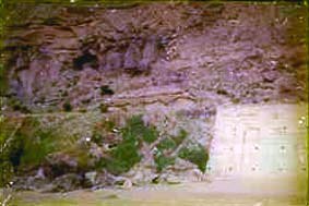
In 1971 we carried out an inspection of parts of the South Coast of San Miguel, the largest of the Azorean Islands. At one point, we found the remnants of a large, boulder filled, river-bed truncated by the shoreline. The rounded boulders were smoothly water-worn and massive (up to two feet across). The river bed, if we remember correctly, was some two hundred and fifty feet from bank to bank; but there was now insufficient width of island to sustain such a river. The boulders were so worn that they had, obviously, travelled a considerable distance, and a strong current of water with a head of thousands of feet would have been required to transport them. There was no room on the narrow island for such a current to be fostered - the rivers source must have lain to the north, on the flanks of a high mountain range. The present mountains on San Miguel are only a little over 3,000 feet high; and we estimate that it would have required a fall of at least 10,000 feet to have reduced boulders of that size, and hardness, to the degree of roundness which they profess.
Google map pin pointing the location of Atlantis with pictures
This discovery so intrigued us that we started an investigation of the mapped sea-bed around all of the islands, with remarkable results. We started with the 1:1 million scale Admiralty Chart - Arquipelago dos Acores - the numerous soundings of which gave a very good general view of the configuration of the sea bed over the whole group of Azorean islands, covering, from east to west - Ilheus das Formigas, Santa Maria, Sao Miguel, Terciera, Soa Jrge, Graciosa, Pico (with its 7,613 feet high, conical, volcanic peak). These were supplemented by larger scale charts where they were available.
We started by contouring the sea bed at intervals of 100 fathoms (600 feet), and it immediately became clear that the river systems that now modestly drain the southern flanks of Sao Miguel were merely head-water tributaries whose channels continued far out to sea, joining into one great, winding, submarine valley some 40 miles further to the south. Other islands contributed similar results and, outstanding, were the triple group of Fial, Sao Jorge and Terciera whose combined results spawned two long river-like valleys which joined into one large valley to give a system that extended for 180 miles.
The whole of the Azorean island group was separated and surrounded by a net of submarine valleys that had all the hall-marks of having once been river valley's on the surface. The Azores could - and probably had, within comparatively recent times - sunk by many thousands of feet.
The next step was to decide whether it was possible to detect any particular contours which might point to an ancient shore line pre dating the sinking of the area. In the south, there was a clear break in gradients around the 1,900 fathom (11,400 feet) contour where a very extensive plain dipped sharply into deeper water. In the north, much the same had happened but at a considerably more shallow depth.
It began to look as if a large land mass, 450 miles across from east to west, and 300 miles from north to south, had tilted from north to south and had sunk beneath the waves, leaving only its mountain peaks showing above the waters - peaks which now form the ten islands of the Azores.
After further calculation, we reached the conclusion that the tilting, either before or during foundering, had been of the order of 0.4 degrees, as a result of which the south coast had sunk more than 11,000 feet and the north coast only some 6,000 feet.
We then reconstructed the land profiles to the approximate positions in which they should have been before the catastrophe. We re-contoured the whole area, raising the north coast by 6,000 feet; the south coast by 11,000 feet; and the intervening area proportionally to the adopted gradient. The result was the outline map shown below.
It was now possible to visualise a great island about the size and shape of Spain, with high mountain ranges rising over 12,000 feet above sea level and impressive rivers running in curving valley systems. In the southeast, a feature which we have called 'The Great Plain' covered an area in excess of 3,500 square miles, and was watered by a river comparable in size to the River Thames in England. It has, and we shall sea, points in common with the great plain described by Plato in his Critias, as being a feature of the Island of Atlantis.
The study on which we have embarked has two parts. The first is to establish that a large island could have existed in mid-Atlantic in Pre-historic times; the second is to determine whether there could have been a connection between the inhabitants of such an island and our heroes - The Shining Ones.
In our judgement,
the first of these parts has been successfully determined; and
it is proper, therefore, to proceed with an examination of Plato's
detailed description of Atlantis and its inhabitants.
Extract from Chapter 18 The Shining Ones by Christian and
Barbara Joy O'Brien
|
|
|
|